
This post is part of a symposium on the LPE of Rural America.
***
Broadband access in rural, remote, and tribal areas in the United States is not only a market failure, but a market disaster. Despite positive externalities for education, health, economic development, quality of life, public safety and civic engagement, all of which suggest the need for public governance, broadband rests squarely in the hands of the private market. Indeed, 17 states actively prohibit or inhibit public broadband options. The private market has little interest in serving expensive, hard-to-reach places that are unable of generating necessary returns on their investment. As a result, broadband infrastructure fails to reach many rural communities, contributing to what is known as the rural-urban digital divide.
For two decades federal subsidy mechanisms have existed to incentivize private companies to connect the unconnected. Indeed, from 2009 to 2017, $47 billion was spent on this endeavor alone. And yet, the broadband infrastructure gap prevails. In the latest attempt to correct this market failure, Congress allocated $42.5 billion for broadband deployment as part of 2021’s trillion-dollar Infrastructure Investments and Jobs Act (IIJA). Every state is guaranteed at least $100 million, while the remaining funds will be distributed to states based on the number of un- and under-connected communities in their jurisdiction. To determine who is un- and under-connected, the government relies on the Federal Communication Commission’s (FCC) national broadband map. As I argue in this post, the FCC’s broadband maps—which themselves have been outsourced to private actors—have consistently exaggerated broadband availability, depriving many rural communities of much-needed funding and a voice in this critical infrastructural issue.
The Politics of Mapping
Maps have long been the basis by which certain policy decisions are made and policy actions taken. We trust maps because of their supposed ideological neutrality; how could our Google map directions to the nearest gas stations have a politics? But maps are anything but neutral. “Behind the map-maker,” wrote geographer J.B. Harley, “lies a set of power relations, creating their own specifications.” Maps are loci of power, signifiers imbued with meaning by their authors. They are also objects of power, exuding truth claims that prime their users to decide what is “true”, “factual”, and “correct.” Maps, as Specht and Feigenbaum teach us, “shape users’ spatial imaginations.” They literally tell us what is there and what is not, and, by extension who is there and who is not; who counts and who doesn’t. As David Harvey argues in Spaces of Capital:
The supposed neutrality of geographical knowledges has at best proven to be a beguiling fiction and at worst a downright fraud. Geographical knowledges have always internalized strong ideological content. In their scientific (and predominantly positive) forms, natural and social phenomena are represented objectivity as things, subject to manipulation, management and exploitation by dominant forces of capital and the state.
The FCC has a troubled history when it comes to broadband mapping. Previous iterations of the broadband map have been deeply flawed, assessing connectivity by the census block rather than the address or parcel. This meant that so long as one building in a census block is connected or can be connected within 10 business days, the entire block was considered 100% served with broadband and therefore ineligible for future funding. While a metropolitan census block might encompass a couple of streets, a rural census block, such as one in Alaska, can cover 8500 square miles. By relying on census blocks, the FCC’s map erroneously painted a picture of a connected America, with some suggesting the FCC exaggerated broadband availability by upwards of 50%. Such gross exaggeration was particularly detrimental for rural, remote, and tribal areas, where a misleading “served” status rendered communities ineligible for funding and thus permanently stuck in what the Wall Street Journal once called “the dial up age.”
The FCC also allowed internet service providers (ISPs) to self-report coverage and permitted the reporting of advertised rather than actual speeds. Depending on the technology deployed, there can be massive differences between the hypothetical speed limit of the network and the actual experience of the user. Weather, distance from the node, users on the network, and trees blocking line of sight can all diminish speeds of technologies like fixed wireless, mobile, coaxial cable, and digital subscriber line (DSL). Only expensive fiber optics—ranging from $27,000 to $100,000 per mile—are immune to these network interreferences.
Detrimental to rural communities, the FCC’s broadband maps supported large broadband providers, who are “are heavily incentivized to overstate speed and availability to downplay industry failures.” Said differently, it looks a whole lot better for national providers to advertise a covered US, rather than a patchwork US. The result of the FCC’s pre-2022 maps therefore was a depiction of a connected America with high-speed internet that favored national broadband providers and dismissed the lived, unconnected and under-connected experiences of rural, remote and tribal communities.
New Map, Same Problems
In 2020, Congress passed the Broadband DATA Act requiring the FCC to revise its broadband data methodology and map. While the maps are crucial to demarcate where the private market has failed and where public intervention is necessary, the FCC ceded its mapping authority to CostQuest, a GIS company that now holds proprietary ownership over the initially-collected data. The first iteration of the FCC’s “new” map was released in November 2022. The new map abandoned census blocks in favor of a “location fabric,” which allowed for more granular depiction of connectivity at the address level. A coverage layer sits atop the location layer, allowing users to find their location on the map and determine the available coverage.
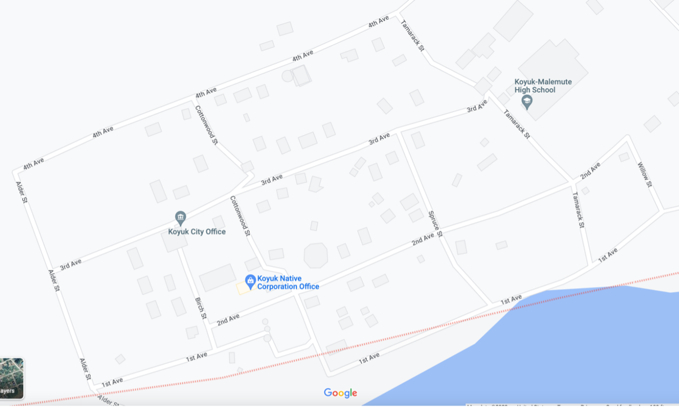
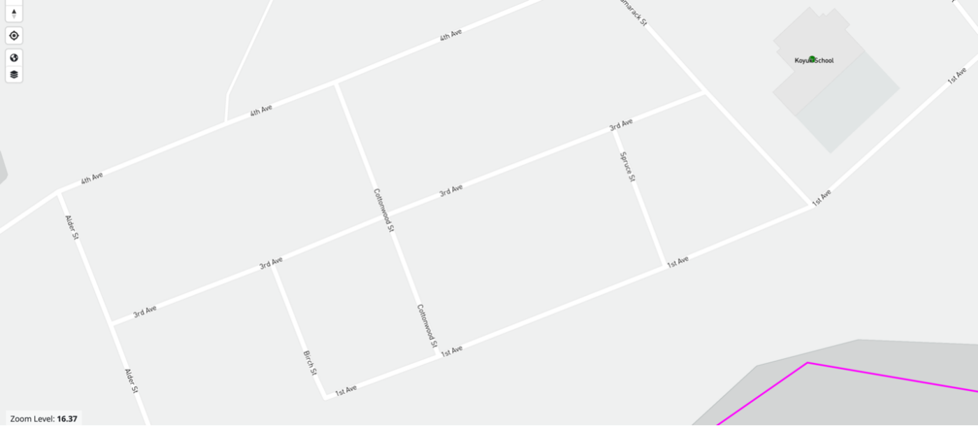
The new maps suffer from three significant problems. First, data is once again self-reported by industry and again, allows providers to report advertised speeds. Second, ISPs claim to cover houses where no such coverage exists or coverage is overstated. The state of Vermont, for instance, found over 20,000 addresses that had errors in the reported broadband service. This could result in the state losing out on millions of dollars in broadband funding. Third, houses, neighborhoods, and in some instances, entire communities are absent from the map – a process that I am calling “digital deletion.” New York State, for instance, reported that some 31,000 locations were missing from the location fabric. Back in Vermont, a reported 22% of locations were absent from the map. Some of the most egregious examples of digital deletion are found in the rural tribal communities of Alaska. Take, for instance, the town of Koyuk, home of the federal-recognize tribe of the Native Village of Koyuk. The town’s population is 243 according to the 2020 census. Demographically, Koyuk’s population is 98% American Indian and Alaska Native. As you can see below, a Google Map image finds multiple edifices in a cross section of the town. The FCC’s map, by contrast, depicts the town of Koyuk without any buildings at all.
To be sure, this is an egregious example of digital deletion, and its usage here is meant to underscore the deeply problematic and systematic erasure of rural, remote and tribal communities in the United States. Historically, tribal communities have received the brunt of this neglect, which recalls digital technology scholar Marisa Duarte’s critique that “policymakers in Washington DC, by not considering the rules of tribal sovereignty develop policies that preclude tribal peoples from creating the programs and services they need for self-governance goals.” Broadband, as Duarte brilliantly argues, is a crucial element towards “network sovereignty.” As the above demonstrates, history is repeating itself.
There were two challenge processes available to those who find themselves incorrectly represented on the new maps. I say were available because the challenge process ended on January 13th, even though the map was only released in November 2022.
If it was a question of broadband service – a “coverage challenge” – a user could challenge the speeds and provisions of ISPs by clicking an icon above the map and filling out the details (oddly, speed test data is considered insufficient evidence for a coverage challenge).
If it was a question about the location itself – a “fabric challenge” – more steps were necessary, including pinning the longitude and latitude. While this may be an easy fix in an urban area where one’s smartphone can provide the exact location of a missing home, mapping an entire community takes time, money, and connectivity, something many rural, remote, and tribal communities do not have. The irony is not lost that to be counted on the broadband map, one needs to have broadband! It also means that communities must actively monitor the broadband map to ensure correctness, even though, as broadband consultant Doug Dawson notes, “there are still a lot of counties that don’t have a GIS mapping system that shows the details of every home, business, land plot, etc.”
America, Online?
What the past and present of the FCC’s mapping efforts demonstrate is an obfuscation of responsibility and a subsumption of what should be a public mapping process to the market. Shifting such crucial responsibility from the regulator to industry serves the political economic interests of both CostQuest and private providers, the latter of which will be the beneficiary of billions of dollars of public investment. On the location fabric side, rural, remote and tribal communities are being systematically erased and thus seeing their digital hopes dashed once again.
Mapping is powerful, and broadband mapping is no different. States, counties, and communities have taken it upon themselves to create their own, participatory-based maps, in hopes of correcting the FCC’s errors once funding is transferred to states. Still, many states will see less money because of the FCC’s maps. The result is the further disenfranchisement of rural, remote and tribal communities. This tension between the rural and the market – one seen repeatedly in the field of critical rural studies – is literally being played out on the broadband map. Such tensions parallel David Harvey’s articulation of the hopes and dreams attached to the map:
Geographical knowledges have the largely unrealized potentiality to express hopes and aspirations as well as fears, to seek universal understanding based on mutual respect and concern and to articulate firmer bases for human cooperation in a world market by strong geographical differences.
In the case of the national broadband map and rural communities, the hope is for a connected countryside; the fear is a private market that refuses to make it happen.

